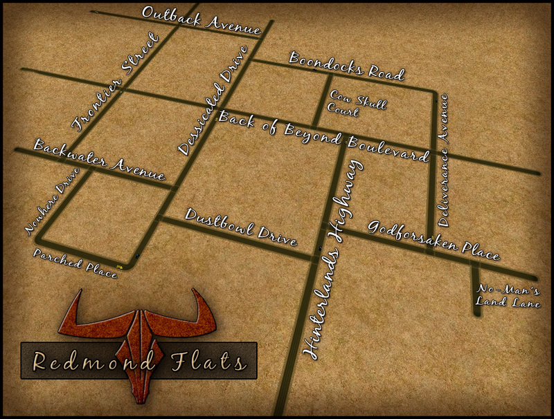
Map & Zoning
(Click the thumbnail above to see the full-size image!)
Zoning
The Commercial Area is the the rectangle defined by:
- The north side of Backwater Avenue between Frontier Street and Dessicated Drive
- Both sides of Frontier Street between Backwater Avenue and Outback Avenue
- The south side of Outback Avenue between Frontier Street and Dessicated Drive.
- The west side of Dessicated Drive between Backwater avenue and Outback Avenue.
- This includes the stretch of Back of Beyond Boulevard that bisects the above-defined rectangle.
- Both sides of Nowhere Drive
- Both sides of Parched Place.
- The south side of Backwater Avenue between Nowhere Drive and Dessicated Drive
- Both sides of Dessicated Drive south of Backwater Avenue.
- In addition, there's:
- The entire north side of Outback Avenue
- Both sides of Frontier Street north of Outback Avenue
- The south side of the west end of Outback Avenue, once it crosses Frontier Street.
- The entire north side of Outback Avenue
- Both sides of all of Boondocks Road
- The east side of Dessicated Drive between Back of Beyond Boulevard and Boondocks Road
- Both sides of Deliverance Avenue north of Back of Beyond Boulevard
- The north side of Back of Beyond Boulevard between Dessicated Drive and Deliverance Avenue.
- This area includes all of Cow Skull Court, which will hold a house for the town's two most affluent families, whoever they turn out to be.
- In addition, there's both sides of the east end of Back of Beyond Boulevard once it crosses Deliverance Avenue.
- Both sides of Hinterlands Highway until it intersects with Godforsaken Place
- The south side of all of Godforsaken Place.
- Both sides of No-Man's Land Lane.
